The short answer
Group whole cities into territories of similar size, using ZIP codes for big cities and county for regional splits. Our Palm Beach County file of 1,590 real estate agencies splits into four territories of 305 to 483 rows each. Count rows per city with COUNTIF or a pivot table, assign each city with XLOOKUP, then filter each territory into its own tab.
A territory split answers one question: which rep, mailing or route owns this row? Get it wrong and two reps call the same office in the same week, or a field rep drives past forty prospects to reach four. Every row in our files carries a full address, city, state, ZIP and coordinates, so the split is a spreadsheet job, not a data-buying job. This guide works through one real file, the Palm Beach County real estate list, and then shows the county-level version on a statewide list.
Pick the unit: city, ZIP, county or radius
| Unit | Best for | Fill in our files | Watch out for |
|---|---|---|---|
| City | Inside sales territories, local campaigns, "we work with agencies in Jupiter" emails | 100% | Postal city names: one big city can hold several ZIPs and neighbourhoods |
| ZIP code | Direct mail, field routes, splitting one big city | 100% | ZIPs are mail routes, not areas; keep the column as text so leading zeros survive |
| County | Regional reps, statewide lists, matching to your CRM's regions | 35.6% as a column; derive the rest from ZIP or coordinates | Some ZIPs cross a county line |
| Radius from a point | Field sales from an office, event invites | 100% (latitude, longitude) | Needs a distance formula; rivers and highways don't show up in miles |
For most teams the answer is cities, grouped. A city is what a rep and a prospect both understand, and it's on every row. Use ZIPs only to break up a city too big for one person, and county when the list covers a whole state.
Worked example: four territories in Palm Beach County
The county has 28 cities in the file, but they're far from equal. Boca Raton alone has 305 agencies and West Palm Beach 250, while Hypoluxo and Atlantis have one each. The top five cities hold 64.0% of the rows. That shape is typical of a metro list and it's why you group cities instead of giving each rep "some cities".
Top cities in the Palm Beach County file: listings and listings with an email
ListingsWith an email
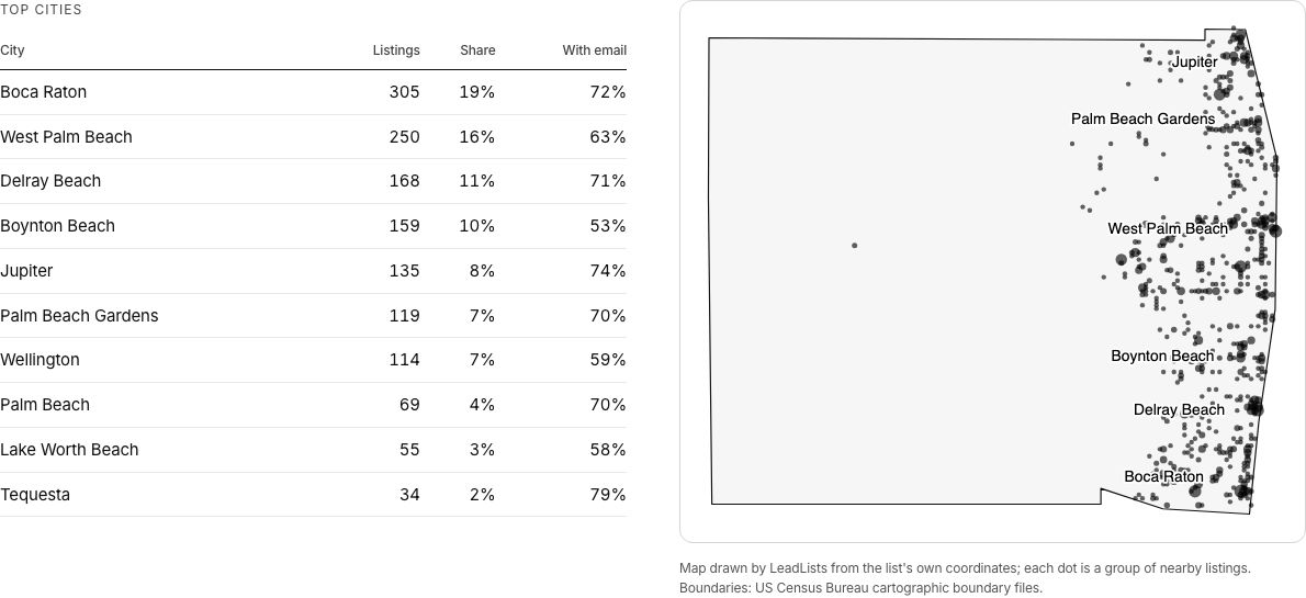
The map shows the geography: nearly everything is on the coast, about 40 miles from Tequesta down to Boca Raton. So we sorted the 28 cities by latitude and cut them into four contiguous groups, keeping every city whole. Boca Raton is big enough to be a territory on its own. The result is four territories of 305 to 483 rows.
Four city territories, rows per territory
Balance by the channel you'll use, not only by row count. If the team works by email, compare rows with an email: North county has 258 (72.7% of its rows) and Boca Raton 219 (71.8%), against 271 in Lake Worth to Delray (60.6%). Those three are close. If they call, nearly every row has a phone (between 98% and 99% in each territory), so row count is the right measure.
The spreadsheet steps
- 01
Count rows per city
A pivot table with city as rows and a count of business, or the COUNTIF formula below. Sort it largest first.
- 02
Draw the territories on paper first
Use the list page map or the latitude column to put cities in geographic order, then group neighbours until each group is near your target size.
- 03
Build a lookup tab
Two columns: City and Territory. One row per city, including the one-listing towns.
- 04
Assign every row
Add a Territory column with XLOOKUP or VLOOKUP. Anything returning "Unassigned" is a city you forgot.
- 05
Split into tabs or files
FILTER each territory into its own tab, or filter and export one CSV per rep for import.
- 06
Check the totals
The territories should add up to the file's row count. Ours: 355 + 483 + 447 + 305 = 1,590.
Count rows per city (city in column P; check your header row)
  Excel / Sheets:  =COUNTIF(P:P, "Boca Raton")
  Sheets, all cities at once:
=QUERY(A:AP, "select P, count(A) where A is not null group by P order by count(A) desc", 1)Assign a territory (lookup tab named Territories: City in A, Territory in B) Excel 365: =XLOOKUP(P2, Territories!A:A, Territories!B:B, "Unassigned") Sheets: =IFERROR(VLOOKUP(P2, Territories!A:B, 2, FALSE), "Unassigned")
Pull one territory into its own tab (Territory in the first empty column, AQ)
  Excel 365 / Sheets:  =FILTER(A2:AQ1591, AQ2:AQ1591 = "North county")
Splitting by ZIP for mail and field routes
Use ZIPs when one city is too much for one person, or when you mail. The Palm Beach file has 50 ZIPs and 41 of them have at least 10 agencies, so ZIP-level routes are practical. The busiest ZIPs are not all in the biggest city: Wellington's 33414 tops the list.
| ZIP | Main city | Listings | With email |
|---|---|---|---|
| 33414 | Wellington | 86 | 62.8% |
| 33432 | Boca Raton | 82 | 80.5% |
| 33483 | Delray Beach | 71 | 74.6% |
| 33480 | Palm Beach | 68 | 69.1% |
| 33411 | West Palm Beach | 68 | 58.8% |
| 33401 | West Palm Beach | 66 | 78.8% |
| 33418 | Palm Beach Gardens | 63 | 68.3% |
| 33426 | Boynton Beach | 59 | 61.0% |
Keep ZIPs as text (leading zeros matter in New England and New Jersey)
  Excel:   =TEXT(S2, "00000")
  Sheets:  Format > Number > Plain text, before pasting

Group by 3-digit ZIP prefix (one regional mail sorting area)
  Excel / Sheets:  =LEFT(TEXT(S2, "00000"), 3)

Distance in miles from your office (latitude in AN, longitude in AO;
office latitude in $AS$1, longitude in $AT$1)
  =3959 * ACOS(COS(RADIANS($AS$1)) * COS(RADIANS(AN2)) * COS(RADIANS(AO2) - RADIANS($AT$1))
+ SIN(RADIANS($AS$1)) * SIN(RADIANS(AN2)))County territories on a statewide list
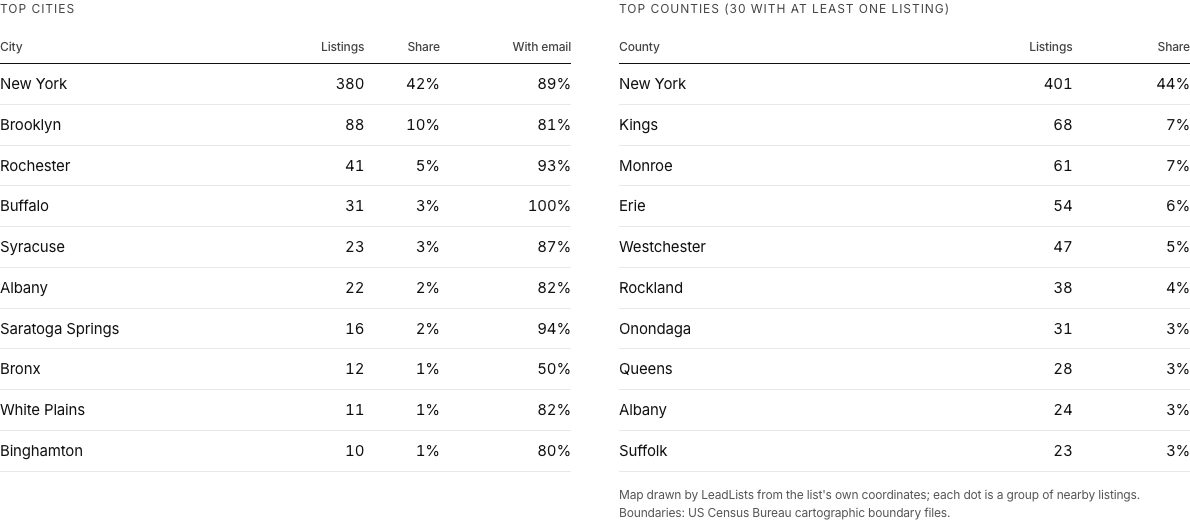
On a state list, counties are the natural unit for regional reps. Our New York advertising agencies list has 907 agencies in 30 counties, and New York County (Manhattan) alone holds 401 of them, 44%. A sensible split is Manhattan; Brooklyn, Queens and the rest of the city; the Hudson Valley and Long Island; and upstate (Monroe, Erie, Onondaga, Albany).
Where the county column is blank (it is filled on 35.6% of rows across all our files), derive it from ZIP with the HUD-USPS ZIP crosswalk, a free file that maps each ZIP to the county or counties it covers. Use the county with the largest share of addresses when a ZIP crosses a line. Then run the same lookup-and-filter steps above, with county in place of city.
Keep territories fair after the split
The first split is the easy part. Territories go wrong over the following months, when new rows arrive, a rep leaves, or one area turns out to answer far more often than another. A few rules prevent most of the arguments.
- Assign by city, never by row. When a new list arrives, every row in Jupiter goes to whoever owns Jupiter. The lookup tab does this for you; a new city that returns "Unassigned" is a decision for the manager, not the first rep to spot it.
- Balance on reachable rows. Compare territories on rows with the channel you use. In Palm Beach County, Lake Worth to Delray has 447 rows but its email rate (60.6%) is twelve points below North county's (72.7%), so an email team would want more of it.
- Keep chains in one place. Brokerages and franchises often have offices in several cities. Decide whether the head office's owner works every branch or each rep works their own, and write it down.
- Review quarterly, not weekly. Move a city only when the numbers say so, and move whole cities. Re-cutting every month resets every rep's pipeline.
- Use the same territory names everywhere. The value in your Territory column should match the owner or team field in the CRM exactly, so imports route themselves.
- Mailings follow ZIP, calls follow city. Postal sorting and print vendors work by ZIP; people say they're "in Wellington". Keep both columns, and pick the one that fits the job.
Inside sales territories
- Grouped cities of similar size
- Balanced on rows with an email or a phone
- Time zone matters more than distance
- Re-cut quarterly at most
Field sales and mail
- ZIPs or a radius from the office
- Balanced on drive time and stops per day
- Coordinates and full address on every row
- Routes rebuilt as new rows arrive
Once territories are set, import each rep's rows with their owner field filled (see import a lead list into your CRM), and give callers the hours column so they dial each area when it's open (cold calling small businesses). If you're still choosing where to sell, business email rates by state shows which states publish the most emails, and buy vs build a lead list compares the cost of making the file yourself.